NEWBERRY COUNTY — As hurricane Ian approaches the U.S., Severe Weather Liaison Frank Strait, with the State Climate Office in the S.C. Department of Natural Resources, is warning local residents that the storm is “not just a coastal event.”
All areas of South Carolina are subject to seeing impacts from Ian, he said.
“The combination of Ian and a warm front lifting northward across the state ahead of the storm will cause heavy rainfall across South Carolina,” said Strait. “The Coastal Plain and the mountains are at the greatest risk for excessive rain and the flooding risk will be greatest in the Lowcountry and western Upstate, where rainfall has been above average over the last month.”
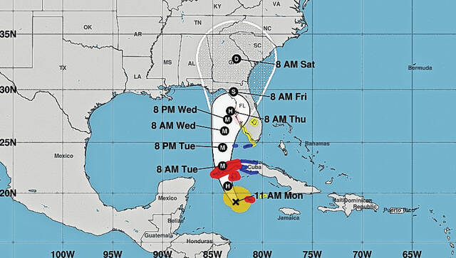
According to Tuesday morning models, persistent onshore flow will result in coastal flooding — primarily at high tide, beginning Wednesday and continuing through Saturday. Major coastal flooding is likely Thursday through Saturday at high tide and heavy rain at high tide would make this even worse, he said.
“Ian will likely spend enough time crossing land in Florida and Georgia before reaching South Carolina to keep us from seeing the hurricane-force wind,” said Strait. “However, there is still a chance for sustained tropical storm-force wind along our coast on Saturday, particularly in the Lowcountry. Saturday may also bring isolated gusts over 40 mph to much of the state.”
While the extent and timing are not yet certain, there will likely be a risk for isolated tornadoes over a large part of the state, especially the Coastal Plain, on Saturday, according to SCDNR.
“It’s still early, things could still change, but there is more confidence in the forecast than yesterday,” he said.
Strait said what is most likely is for the rain to spread over the Coastal Plain Friday morning as Ian’s northward march forces a stationary front to the south to move northward as a warm front. The rain spreads northwestward over the rest of the state through Friday night.
“The heaviest rain will likely be over the Lowcountry, where flooding is likely, particularly along the coast,” he said. “Persistent onshore flow will push water into the coastal areas, leading to major flooding at high tide and the heavy rain at the same time would make the coastal flooding even worse — Charleston, y’all know this drill.”
The onshore flow can be quite brisk and gust over 40 mph at times. In fact, some inland areas along the Coastal Plain can see gusts to around 40 mph during this time as well, he said.
“On Saturday, slow-moving Ian will be pushing northward through eastern Georgia and likely into South Carolina — this is when we have a chance to see stronger winds along our coast reaching tropical storm force,” said Strait. “A farther west track would mean less risk for strong wind, while a farther east track would increase the wind risk along our Coastal Plain. As Ian moves through the state, more rain will fall, heavy at times, Saturday night. This is when we would have the potential to see isolated tornadoes, with the area east of the track of Ian’s center experiencing that risk.”
The heavy rainfall likely ends Saturday night, but a few showers may linger through Sunday. The wind will turn offshore, which will stop the coastal flooding, he said.
“While some changes to the forecast are likely, I think we have a good general idea about how Ian will impact us,” said Strait. “Stay tuned to your favorite weather outlet for the specifics for your backyard, and have your disaster kits ready before Ian arrives.”
Leave a Reply